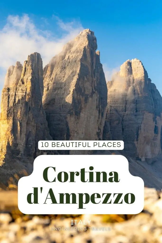
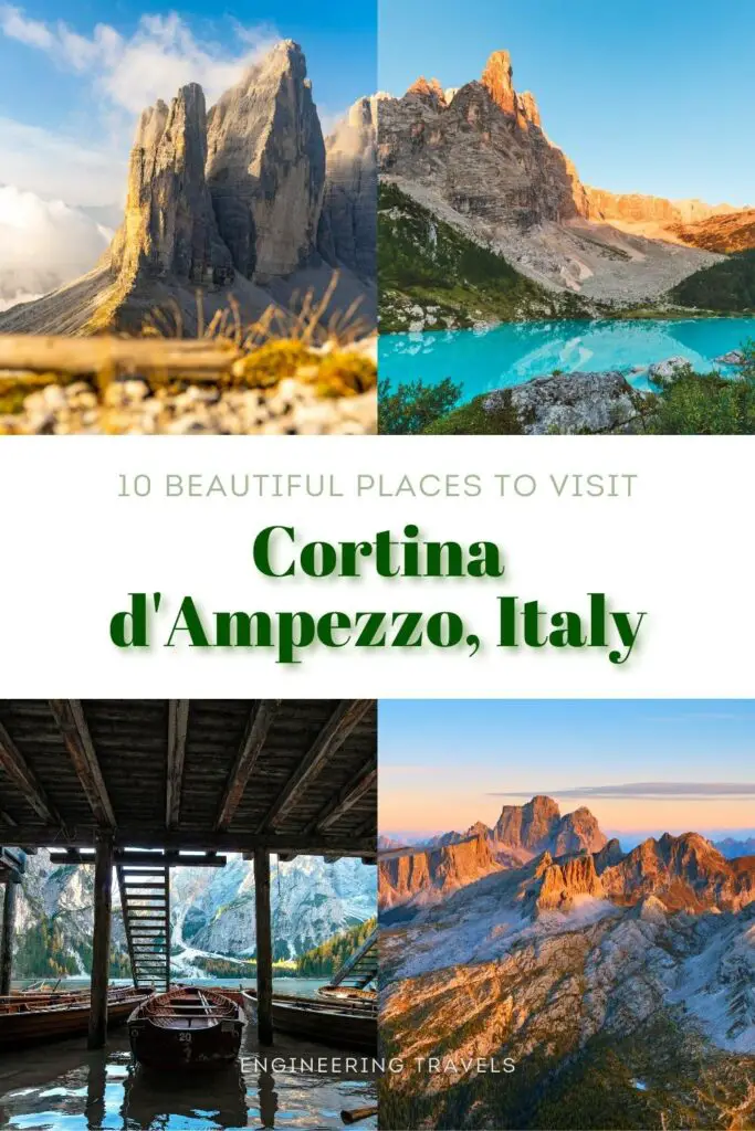
10 Beautiful Places Around Cortina d’Ampezzo Italy to Visit
Planning a visit to Cortina d’Ampezzo or already soaking in its beauty?
Wondering which part of the Dolomites to explore next?
I’ve got your back! In this blog post, I present not just a list of picturesque places near Cortina d’Ampezzo but also a handy map, their distances from Cortina d’Ampezzo, estimated travel times, and more!
Make sure to read till the end, as this post is packed with useful information!
This post contains affiliate links. I may receive a tiny commission at no additional cost to you.
Use the table of contents to skip to topics.
Out of all the top destinations in the Alps that I know, including Jungfrau Region, Zermatt, Bavarian Alps, and Chamonix in the French Alps, the Dolomites, where Cortina d’Ampezzo is located, are by far the most challenging to reach and explore. Nestled deep in the heart of the Italian Alps, the majority of the Dolomites can only be accessed by private vehicle or bus, and even then, the bus service can be inconsistent and unreliable.
Despite these hurdles, the Dolomites are home to some of the most awe-inspiring natural beauty in the Alps, rivaling the heavenly Lauterbrunnen in Switzerland.
If you’re wondering whether Cortina d’Ampezzo is worth a visit, let me tell you, it’s an absolute gem in the Dolomites. Though it may not be the easiest place to get to, the stunning craggy mountain ranges that surround the town alone make the journey more than worthwhile. At the same time, Cortina d’Ampezzo is perfectly located at the heart of the Dolomites, making it an ideal base for exploring the region.
Are you planning a quick trip to the Dolomites from Cortina d’Ampezzo? There are some stunning places you simply can’t miss. The list is quite extensive, but let’s focus on the top ten nearest to Cortina d’Ampezzo, starting with the majestic Cinque Torri.
Discover: Best hotel deals in Cortina d’Ampezzo.
1. Cinque Torri
Driving a car is a great option to explore Cortina d’Ampezzo. But you don’t need a car to see some of the most beautiful places around. Take Cinque Torri, for instance. This is a gorgeous location close to Cortina d’Ampezzo that you can access with only a bus and a chair lift from the town center!
Here are the directions to get there.
- From the Cortina d’Ampezzo bus terminal, hop on bus #030 heading to Falzarego Pass
- Then, drop off at the 11th stop or Cinque Torri bus stop.
- Walk for a few minutes, and you will arrive at the Cinque Torri (5Torri) chair lift station.
- The chairlift will bring you to Rifugio Scoiattoli, where you can already see Cinque Torri and start hiking around it.
If you’re driving a car to Cinque Torri, you can find a parking spot next to the Cinque Torri chair lift station. It’s only 13.3 kilometers from the town center, and you can get there in about 20 minutes under normal conditions.
See the route to the Cinque Torri chair lift station in Google Maps.
There’s a hiking trail under the Cinque Torri cableway that seems to be a ski route. It’s only 1.5 kilometers (0.93 miles) long, but it climbs up 330 meters from the chair lift station to Rifugio Scoiattoli.
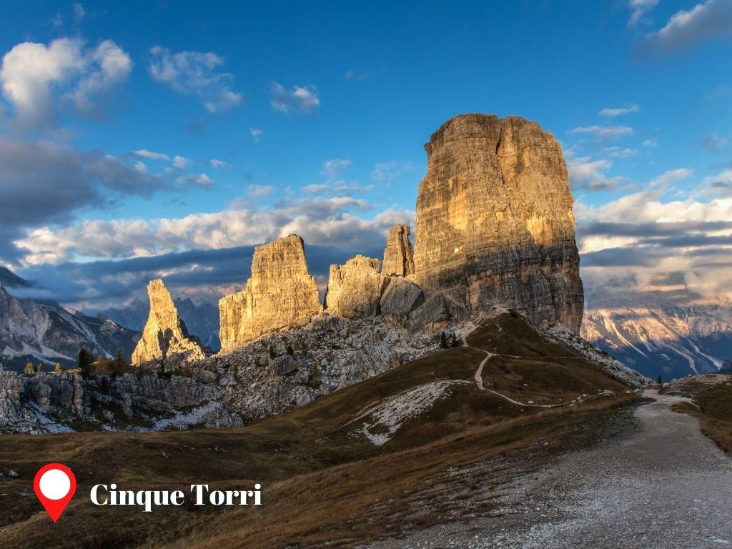
So, why visit Cinque Torri?
Cinque Torri is both a historic and scenic destination. Its spectacular five towering and gigantic dolomite peaks bear witness to the battles in the Italian Alps during the Great War (WWI). Here, you can find an open museum, the Museum of the Great War, right at the foot of the giant rocks.
The five peaks of Cinque Torri are also a favorite destination for extremely adventurous people like rock climbers. Sometimes, you will see people walking on a tightrope from one peak to another. You can spot them when you start hiking the trails around Cinque Torri.
The hiking trails around Cinque Torri are well-signed. You won’t get lost, especially during peak season when you can just follow other people hiking around Cinque Torri as well. The path inclination can go as high as 30%, especially on the eastern and southern sides of Cinque Torri.

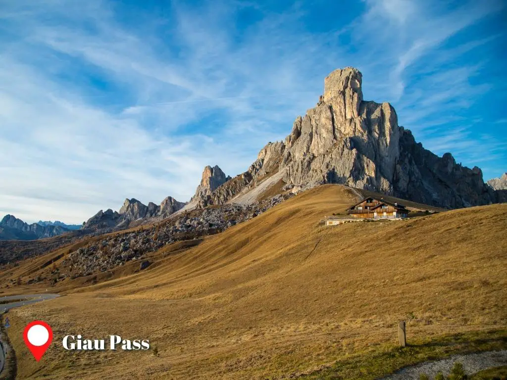
2. Giau Pass
Giau Pass, one of the most scenic passes in the Dolomites, is the second beautiful destination around Cortina d’Ampezzo. It’s situated southeast of Cinque Torri and at the foot of the 2572-meter mount Nuvolau.
Here, you’ll witness the spectacular rocky outcrop of Mount Nuvolau, also known as Ra Gusela, jutting out of the vast meadowy fields. Its triangular shape will leave you in awe of how creative nature can be.
Giau Pass links Cortina d’Ampezzo to its southern neighbors, Colle Santa Lucia and Selva di Cadore, and is a historic mountain pass once part of the Venetian-Austrian border back in the 18th century.
If you’re already in Cinque Torri, there are several hiking paths you can take to get to Giau Pass.
One of the best is the trail between Averau and Nuvolau peaks, which features Rifugio Averau, a scenic spot to stop for a refreshing meal (Trail 439, 441, 452). The slope incline is steep before and after the Rifugio, but the rest of the trail is mostly flat. On the east side of mount Nuvolau, Trail 443 is about the same length but may be harder to hike.
If you’re planning to visit Giau Pass from Cortina d’Ampezzo, your best bet would be to drive using SR48 and SP638. Starting from Cortina, head south towards Pocol and take the road that leads into the forest. In about half an hour, you’ll arrive at Berghotel Passo Giau, where you’ll be greeted by a stunning view of the mountain pass.
Another option would be to take bus #004 or #030, which can take you straight from Cortina d’Ampezzo to Berghotel Passo Giau. However, do note that these buses are only available during peak season or summer months. Check if the route is available using Moovit or Dolomiti website (Italian) before you visit.
If you’re heading east from Berghotel Passo Giau, you’ll come across a small lake that’s only about 750 meters away. This spot is perfect for upgrading your photography game, especially if you’re looking to capture a reflection shot of Mount Nuvolau or Ra Gusela on the lake’s surface.
If you’re facing Mount Nuvolau, the lake will be to your right. The small lake may exist depending on the weather. Here’s what the spot around the small lake looks like:
3. Mondeval Plateau
Near Berghotel Passo Giau, there is a small church called Chiesa di San Giovanni Gualberto. From there, you can take the Trail 436 to an “interesting” and panoramic Mondeval Plateau.
Mondeval is a plateau with a unique landscape of rolling fields and cliffs – straight out of a movie! The saddle of Becco di Mezzodi, seen near Forcella Giau, is one of Mondeval’s most spectacular features.
But did you know that Mondeval Plateau is a burial site of a Mesolithic Hunter? Yes, you read it right – a Mesolithic Hunter was buried in Mondeval Plateau, and his skeleton was found by a team of researchers next to a boulder at the lowest point of the plateau. Studies found out that this hunter lived 7500 years ago.
However, the remains were already transferred for preservation to the Museum Vittorino Cazzetta in Selva di Cadore. Anyway…

Mondeval Plateau is a basin-shaped plateau surrounded by peaks and elevated cliffs. Here, you can get a clear view of its form from Forcella Giau, Forcella Ambrizolla, and the summit of Monte Mondeval. These are the plateau’s raised edges, overlooking the whole place.
Where are the most scenic spots in Mondeval Plateau?
Well, almost everywhere in Mondeval Plateau is scenic. But for me, the most stunning places are the summit of Monte Mondeval, Lago de Baste, and somewhere around the boulders near Forcella Giau.
The boulders are the first scenic spot you can get to if you start hiking from Forcella Giau. See its exact location (46.471460, 12.079081) on Google Maps. Here, you can see the amazing saddle between the summit of Monte Mondeval and Piza del Corvo from the boulders, and it’s breathtaking! On a clear day, you can also see the rugged peaks of Monte Pelmo and Monte Civetta behind the saddle.
Laghetto di Baste (46.467662, 12.081836), the only lake in the Mondeval Plateau, is visible from the boulders too. It’s in the middle of the basin-shaped plateau, a bit lower than the surrounding fields. So, you can’t see much of the mountains beyond the plateau from there. Laghetto di Baste is a good place to go if you want to see Monte Pelmo. This is the only mountain outside the plateau that is visible from this tiny lake.
You can also capture Monte Pelmo with its reflection on the water. But this relies on the weather and the water’s stillness. You can also see the face and peak of Lastoni di Formin mirrored on the surface of Laghetto di Baste.
Where is Lastoni di Formin? It is the rock mountain with a spectacular eroded face that forms the north wall of the Mondeval plateau. This enormous mountain runs along the whole hiking trail in the Mondeval basin.
Just south of Lastoni di Formin, you’ll find the peak of Monte Mondeval, a vantage point that offers truly sensational views. Standing at the coordinates 46.459930, 12.082932 (its peak), you’re treated to a stunning panorama that spans 360 degrees. Starting from Lastoni di Formin and moving clockwise, your gaze will sweep across Croda da Lago, the Antelao-Sorapis mountain group, Monte Pelmo, and finally Monte Civetta.
The journey along Trail 436 in the Mondeval Plateau begins at Forcella Giau and concludes at Forcella Ambrizolla. While you can complete the hike in about an hour and a half, I’d recommend setting aside an extra hour or two to fully appreciate all the beauty that the Mondeval Plateau has to offer.
Lastly, Mondeval Plateau is “mostly” flat. Slopes along it have a gradient of no more than 20%. Most parts are averaging from 5% to 15%.
4. Croda da Lago
Once you’ve reached the Mondeval Plateau, you’re just a stone’s throw away from another picturesque gem near Cortina d’Ampezzo – Croda da Lago. This spot is home to Lago Federa, a lake of such beauty that words can hardly do it justice!
Croda da Lago is a quaint mountain range located east of Giau Pass and south of the town of Cortina d’Ampezzo. Its highest point, Cima d’Ambrizzola, stands tall at 2,715 meters above sea level. However, the main attraction is undoubtedly Lago Federa.
There are three paths to reach Croda da Lago, all involving several hours of hiking. And if that sounds exhausting, just remember – the breathtaking views waiting for you at Croda da Lago are more than worth the effort. It’s a sight you’ll want to see with your own eyes!
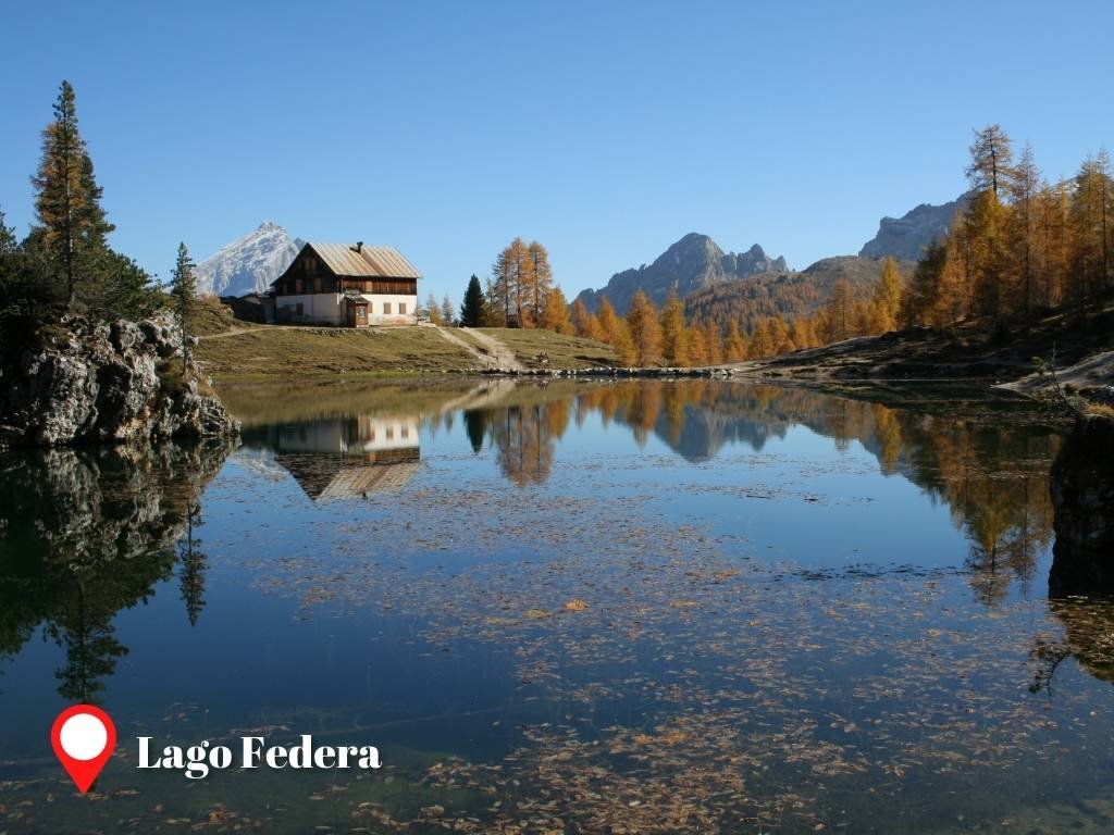
Lago Federa is like something out of a fairy tale, especially when the weather is on your side. Make your way to its northern shore and you’ll be greeted by the sight of the rugged peak of Becco di Mezzodi, pine trees, and mountain huts, all reflected in the lake’s mirror-like surface. It’s a dream destination for photographers, offering some of the most picturesque spots in the Dolomites.
And like many attractions near Cortina d’Ampezzo, Lago Federa features a mountain hut – Rifugio Croda da Lago / Gianni Palmieri – where you can take a well-deserved rest.
Way #1 to Croda da Lago
The first way you can reach Croda da Lago is through Mondeval Plateau, as discussed previously.
You start at Giau Pass, then across Mondeval Plateau to Croda da Lago.
Suppose you brought your car and parked in Giau Pass. Then you need to do a round-trip hike back to Gaiu Pass, and you will probably need a day to finish it. Here’s the summary:
- Start at Giau Pass (Berghotel Passo Giau) and follow Trail #436 until Forcella Ambrizolla
- At Forcella Ambrizolla, proceed to Trail #434.
- You arrive at Lago Federa within 2 hours and 15 minutes, with no breaks during the hike. I suggest allocating 3 hours for a one-way trip.
- To return, just do the reverse.
After reaching Lago Federa, you have another option to continue with Trail #434. It will lead you to a fork (Caşon de Formin) where you can choose between:
- Trail #435 – the other side of Croda da Lago going back to Mondeval Plateau. Distance between Berghotel Passo Giau and Caşon de Formin: 7.7 km, 4 hours to 5 hours.
- Trail #437 – the way to Ru Curto / Pian del Pantan Bus stop (along Giau Pass but still 6.3 kilometers away or a 10-minute drive to Berghotel Passo Giau). Distance between Ru Curto and Caşon de Formin: 1.75 km, 45 mins to 1 hour.
- Trail #434 – the path heading Cortina d’Ampezzo, ends with Peziè de Parù lodge. Distance between Peziè de Parù lodge and Caşon de Formin: 2 kilometers, 1 hour, and 15 mins.
I do not recommend proceeding to Trail #434 away from Mondeval Plateau after reaching Lago Federa if you have brought your car to Berghotel Passo Giau. Nonetheless, you can take whatever trail number you want if you choose the bus to get to the trailheads.
Berghotel Passo Giau, Pian del Pantan, and Peziè de Parù are linked to Cortina d’Ampezzo by buses #030 and #004. Just don’t forget to check the schedules before you go! 🙂
Way #2 to Croda da Lago
The second way to Croda da Lago starts at Ru Curto / Pian del Pantan Bus stop. You can hop on Bus #030 from Cortina d’Ampezzo or bring your car to the trailhead to get started. The parking space is just beside the road and is very limited, especially during the peak season.
Visitors going to Croda da Lago from Ru Curto / Pian del Pantan Bus stop follow a circuit around the mountain. Here are the details of the first part of the circuit:
- From the Ru Curto / Pian del Pantan Bus stop, start your hike on Trail #437 into the forest.
- You should arrive at Caşon de Formin (fork) within an hour. Choose Trail #434, labeled with Croda da Lago. The trail forward will be steep until you reach a lookout overlooking Cortina d’Ampezzo. After that, the path is predominantly flat until you arrive at Lago Federa.
Allocate 2 to 3 hours to reach Lago Federa in Croda da Lago from the Ru Curto / Pian del Pantan Bus stop. To return, you can reverse the steps above or continue with the circuit around Croda da Lago (See details below):
- From Croda da Lago, continue with Trail #434 in the direction of Mount Becco di Mezzodi or Forcella Ambrizzola to the south.
- After reaching Forcella Ambrizzola, turn to Trail #436.
- You must encounter another fork shortly and turn to Trail #435.
- Trail #435 will lead you to Caşon de Formin, where the final leg of the loop begins. Turn to Trail #437 to get back to the Ru Curto / Pian del Pantan Bus stop. Trail #435 is slightly steep around Forcella Ambrizzola and Forcella de Formin, so be careful.
This path goes through the forests (Trail #437 and #434), with several scenic vantage points along the way. It’s a recommended path because it is the shortest you can try, and hiking should feel more restorative because of the trees.
Overall, it’s 13 kilometers of hiking trails, which will require an entire day to finish. Of course, that includes in-between breaks, sightseeing, photographs, lunch, etc.
Way #3 to Croda da Lago
The third way to Croda da Lago is very similar to Way #2. You just start hiking at Peziè de Parù lodge instead of the Ru Curto / Pian del Pantan bus stop.
I do not recommend this route since the path has a low elevation (the first part of Trail #434 before reaching Caşon de Formin), and you’ll see fewer scenic views.
5. Rifugio Faloria
Did you know? There’s a place near Cortina d’Ampezzo that’s simpler to visit than Cinque Torri.
It’s Rifugio Faloria, and it’s only a cable car journey away from the town center. Alternatively, you can hop on buses #030 or #445.
What’s more, the cable car ground station for Rifugio Faloria is situated just beside the bus terminal in Cortina d’Ampezzo. So, you can literally ascend to the mountains the moment you step off the bus in town! How fantastic is that?
Perched atop a cliff at 2,123 meters, Rifugio Faloria offers a bird’s-eye view of the charming town of Cortina d’Ampezzo. It serves as the starting point for extensive hikes and ski routes on Monte Faloria. However, even before you reach the top, the 10-minute cable car ride promises panoramic views that will take your breath away.
Rifugio Faloria also boasts a sunny terrace restaurant, where you can savor delicious meals while soaking in the stunning scenery.
If you’re looking to witness a spectacular sunset over Cortina d’Ampezzo, there’s no better place than Rifugio Faloria. Positioned to the east of Cortina, it offers a front-row seat to the sun setting behind the rugged peaks of the Tofane group, as the town below starts to twinkle with nightlights. Don’t forget to capture a timelapse of this magical moment!
Want some quiet while catching a sunset view over Cortina d’Ampezzo from Rifugio Faloria? Have a quick hike to one of the vantage points in Trail #212 or to the path near the Cliffhanger Lodge.
6. Lake Sorapis
Nestled in the heart of the Sorapis mountain group, you’ll find Lake Sorapis, one of the most stunning locations near Cortina d’Ampezzo. This enchanting lake captivates visitors with its ever-changing hues, ranging from milky blue to opal or turquoise, depending on the season.
Encircled by towering peaks that reach 2,500 meters, Lake Sorapis is a hidden gem in the mountains, its unique color hinting at its secluded charm. This mesmerizing color is said to originate from the dust of the glaciers atop the surrounding peaks.
As you approach Lake Sorapis, you’ll notice a distinctively shaped peak rising above the lake – a feature that adds an extra ‘wow’ factor to this already breathtaking scene. Known as Dito di Dio or God’s Finger, this peak casts a spectacular reflection on the lake’s surface, particularly on bright sunny days.
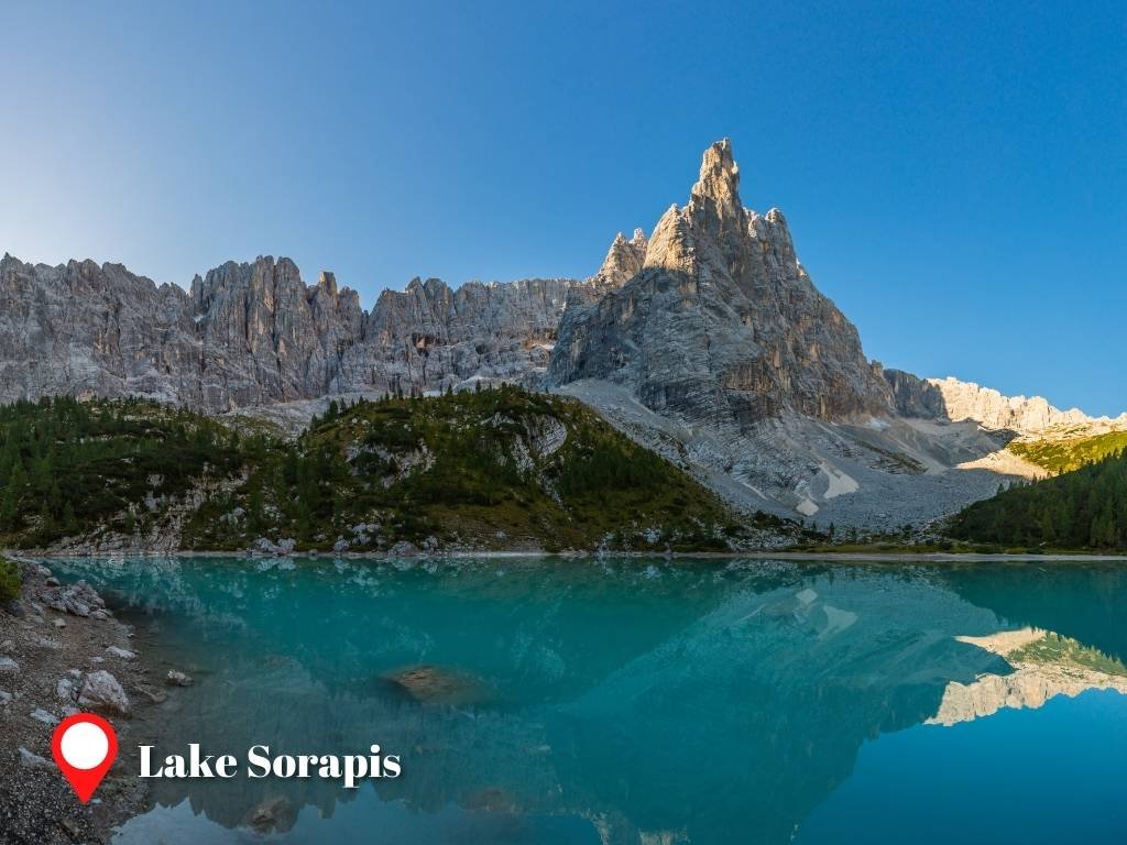
Lake Sorapis is home to its very own mountain hut, Rifugio Vandelli, providing a welcome respite and a chance to refuel after a long hike.
You’ll come across Rifugio Vandelli before reaching Lake Sorapis, but rest assured, you’re already close. Perched at an elevation of 1926 meters, the hut boasts stunning views that stretch as far as Tre Cime di Lavaredo, Misurina, and its lake. The only way to reach Lake Sorapis is on foot.
The trailhead starts just beyond the B&B Hotel Passo Tre Croci Cortina, near the Passo Tre Croci bus stop. You can get there by car or by hopping on bus #030 towards Tre Cime di Lavaredo or Misurina. Parking is available along the roadside, but spaces are limited.
Way #1 To Lake Sorapis
To reach Lake Sorapis, you’ll want to follow Trail #215. Don’t be thrown off by the fact that it’s marked as Rifugio Vandelli – they’re practically in the same location.
The trail spans approximately 6 kilometers and typically takes between 2 to 2 and a half hours to complete. While most of the trail is flat and easy to navigate, there’s a section in the middle where the path becomes steep and presents a bit of a challenge. A part of it needs via Ferrata equipment.
But I found that others made it through even without it. In fact, they are a family, and the kids even aced that part! You’ll also pass a narrow path, and people fearing heights may feel very uncomfortable.
Way #2 To Lake Sorapis
For those who prefer to avoid high and narrow paths, there’s a lower but longer hiking trail available. This route begins with Trail #209 and then transitions to Trail #217.
The starting point for this trail is just beyond the Passo Tre Croci bus stop, a little further along from the trailhead for Trail #215. We can break down this path into two main sections: the first encompasses all of Trail #209 and a portion of Trail #217, while the second completes the rest of Trail #217, leading you right up to Lake Sorapis.
Here’s a detailed comparison of both sections:
First part
- path (unpaved) and hiking path (graveled)
- relatively flat and has a downhill slope (-5% to -15% gradient) when heading to Lake Sorapis
- Approximately 450m downhill
- 5 kilometers
- 1 hour 45 minutes
Second part
- mountain hiking path (alpine)
- steep with an uphill slope (15% to 35% gradient) when heading to Lake Sorapis
- Approximately 600m uphill
- 2.75 kilometers
- 2 hours
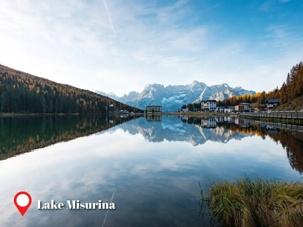
7. Lake Misurina
Not all of us have the luxury of time for lengthy hikes; some of us simply want to unwind and soak in the alpine splendor of the Dolomites.
Picture yourself having a picnic by a serene lake, watching cows graze in lush meadows, or leisurely strolling around capturing beautiful photographs. If this sounds like your ideal day, then Lake Misurina is a must-visit.
There are three compelling reasons to visit Lake Misurina: firstly, its breathtaking scenery that’s worthy of a postcard; secondly, its proximity to restaurants that offer both delicious food and stunning views; and lastly, it’s known for having some of the cleanest air in the region, making it an ideal location for leisurely outdoor activities.
If, like me, you’re sensitive to air pollution, I highly recommend a visit to this area. Breathing in the clean air is not only refreshing, but it also has therapeutic benefits for our lungs! This is why institutions caring for children with asthma are located near Lake Misurina in Italy.
If you’re keen to extend your stay and enjoy more of this fresh air, there are numerous hotels around the lake ready to welcome you. Imagine waking up to a blissful morning with a view of the misty Misurina – it’s truly a sight to behold!
The best time to explore and appreciate the lake is in the morning. As midday approaches, especially during peak season, the area can become crowded with tourists. Cars parked along the roads can detract from the natural beauty of the lake and its surroundings.
For photography enthusiasts, make sure to arrive at Lake Misurina early in the morning. When the lake’s surface is still calm, you can capture stunning images of the Sorapis mountain group reflected in the water. As the day progresses and tourists start renting pedal boats, the tranquility of the water can be disrupted. So make sure to seize the serene early hours for that perfect shot!
By the way, Lake Misurina is commonly frozen during winter. Winter sports are held in it sometimes, though.
Lake Misurina is also extremely simple to visit either by car or public transportation – the reason it gets a lot of tourists. Lake Misurina is approximately 14 kilometers away from Cortina d’Ampezzo, just a 20-minute drive by car and a 30-minute bus ride on bus #030. Anyhow, even before you reach the lake, you’ll be captivated by the breathtaking scenery.
The way is a wide-open space with alpine pastures, and the spectacular rugged peaks of the mountains are in the background. Cima Ovest, Cima Grande, Cima Piccola, and other peaks near Tre Cime di Lavaredo are already seen from this point.
8. Tre Cime di Lavaredo
Tre Cime di Lavaredo, another iconic landmark in the Dolomites near Cortina d’Ampezzo, is a sight you won’t want to miss. Its three distinct peaks, which we mentioned earlier, rise nearly 3000 meters above sea level, piercing the sky with their majestic presence.
Their size, shape, and overall grandeur are a testament to nature’s awe-inspiring creativity. Like Cinque Torri, Tre Cime di Lavaredo holds historical significance as one of the Dolomites’ military sites.
Once marking the border between Italy and Hungary-Austria, it was a battleground during World War I. As you hike around the area, you’ll come across monuments, fortifications, and other remnants of its military past.
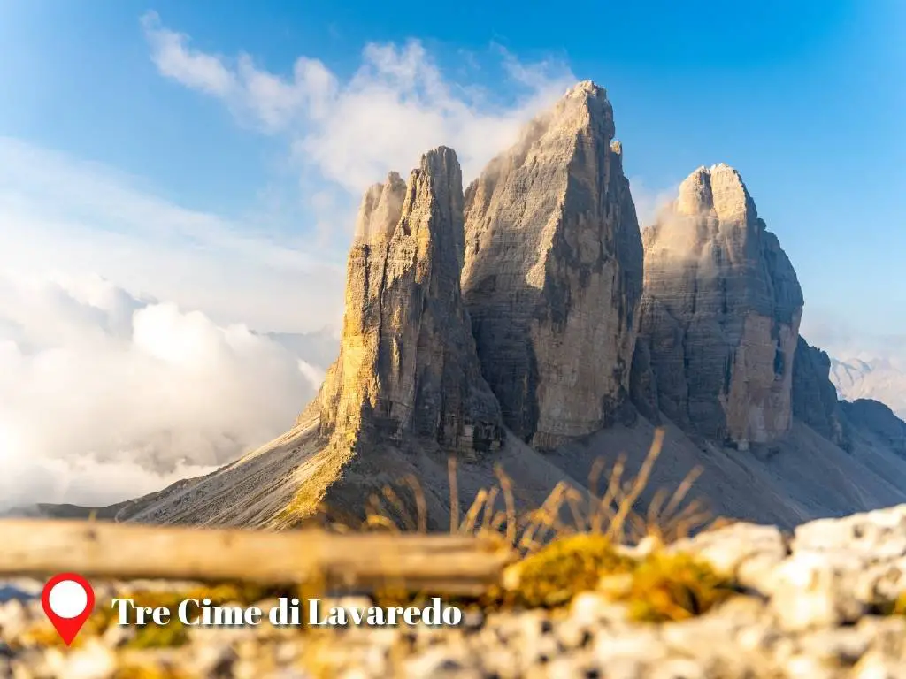
Hiking Trails encircle the three peaks of Tre Cime di Lavaredo. You only have to stay within Trail #101 and #105 to complete the loop. However, you can find shortcuts along the way, discussed later. Here are the landmarks along these hiking trails in a counterclockwise direction:
- Rifugio Auronzo (Start of Trail #101)
- Forcella Lavaredo (Trail #101)
- Rifugio Locatelli (End of Trail #101, turn to Trail #105)
- Malga Langalm (Trail #105)
- Rifugio Auronzo (End of Trail #105)
The trail loop spans a distance of about 9.5 kilometers, a journey that can be comfortably completed in around 3 hours and 30 minutes, assuming no stops for breaks or photos. Nestled near the summit of a towering mountain, the trail offers unobstructed, panoramic views. Every turn presents a new, breathtaking vista for you to admire.
The first half of the loop, stretching from Rifugio Auronzo to Rifugio Locatelli, is relatively easy to navigate. The path is mostly flat and well-trodden, with only a steep incline near Forcella Lavaredo posing any significant challenge.
As you embark on the second half of the journey post-Rifugio Locatelli, prepare for a sharp descent of roughly 200 meters within the initial 1.5 kilometers. But don’t worry, the path soon levels out and alternates between uphill and downhill stretches until you reach Malga Langalm.
Near Malga Langalm, you’ll find quaint little lakes that provide perfect opportunities for capturing mirror-like reflections of the Tre Cime peaks. After passing Forcella Lavaredo, you’ll notice three unmarked trails branching off from Trail 101 towards the west. These are shortcuts leading to Malga Langalm, allowing you to bypass Rifugio Locatelli if you wish.
Are you considering taking a shortcut? If so, I’d suggest opting for the second one, situated roughly 750 meters north of Forcella Lavaredo. It’s a brief 10 to 15-minute hike away.
This particular shortcut offers an optimal vantage point for viewing the north face of Tre Cime di Lavaredo, compared to the first and third shortcuts. Choosing this path shortens the hiking distance to approximately 7 kilometers, a distance that most people can comfortably cover within 2 hours and 30 minutes to 3 hours.
However, if time permits, I’d recommend completing the entire circuit. Especially on clear, sunny days, don’t miss out on visiting Rifugio Locatelli. The area around Rifugio Locatelli offers additional scenic views and picturesque lakes like Laghi dei Piani. Laghi dei Piani, like other alpine lakes, serves as a portal to another dimension. From certain angles, these lakes reflect the majestic mountain peaks in their tranquil waters.
In the case of Laghi dei Piani, you’ll be treated to mirrored images of the rugged summits of Rocca Novale and Monte Paterno.
The most straightforward way to reach Tre Cime di Lavaredo (Rifugio Auronzo) from Cortina d’Ampezzo is undoubtedly by car, whether it’s your own or a rental. The journey spans nearly 22 kilometers and typically takes around 50 minutes to complete. You can check out the route on Google Maps for more details.
The parking lot at the destination is relatively spacious compared to other lots in Cortina d’Ampezzo. However, keep in mind that during the peak season, it tends to fill up quickly. Parking comes with a fee of 30 EUR per car.
If you prefer public transportation, you can take buses #30 or #31 directly from Cortina d’Ampezzo to Tre Cime di Lavaredo (Rifugio Auronzo). Just be sure to check the bus schedule ahead of time.
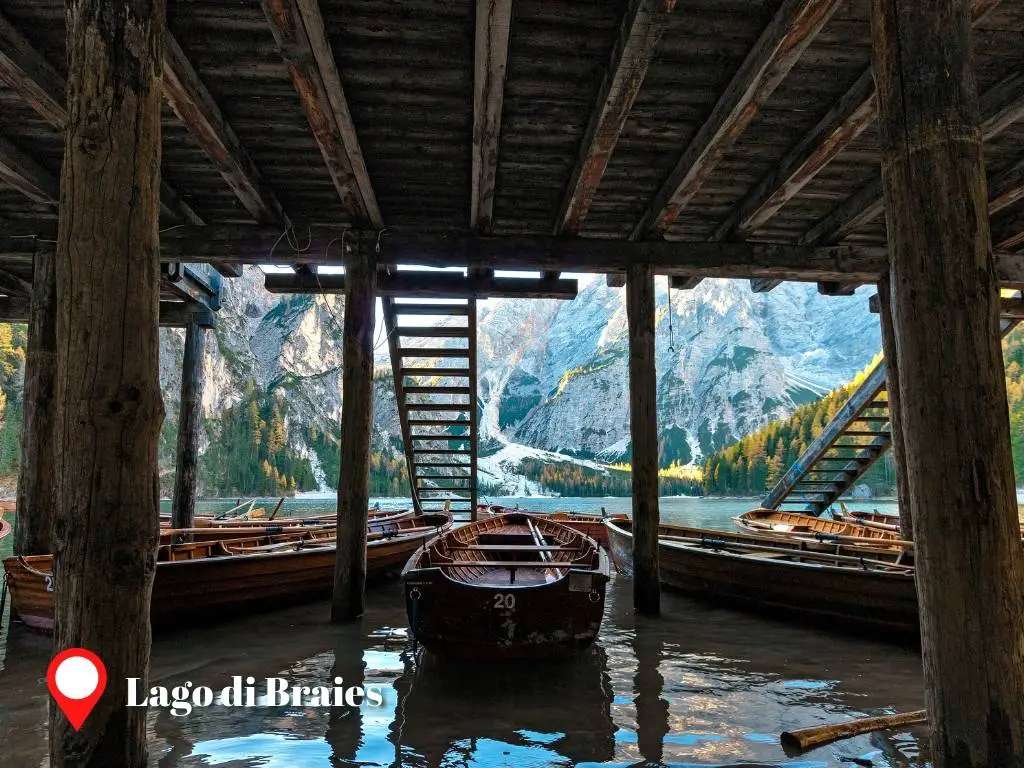
9. Lago di Braies
Another appealing aspect of residing in Cortina is that it’s just a stone’s throw away from the Dolomites’ most scenic and photogenic lake, Lago di Braies. Chances are, you’ve already encountered its captivating allure on Instagram.
The reflection of the mountains on its pristine waters might just be one of the most spectacular sights you’ll ever see. The lake maintains its enchanting charm come rain or shine.
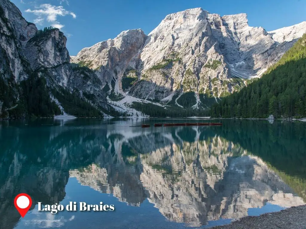
Given its ease of access and immense popularity, Lago di Braies often attracts a large number of visitors. If you’re looking to enjoy the lake’s “enchanting” sunrise in peace, I’d recommend visiting early in the morning before the crowds arrive. However, it’s worth noting that a winter visit might not offer the same experience, as the lake typically freezes over during this season.
While Lago di Braies may be the furthest of all the places mentioned here from Cortina d’Ampezzo, it’s still relatively close, especially when compared to other towns in the Dolomites. Nestled on the northern side of Parco Naturale di Fanes-Sennes-Braies, a car journey from Cortina d’Ampezzo to Lago di Braies takes roughly 45 minutes, covering a distance of 47 kilometers.
If you’re opting for public transportation, the journey from Cortina d’Ampezzo to Lago di Braies will take a minimum of 1 hour and 25 minutes. This involves taking bus #445 from Cortina to Dobbiaco, followed by another bus ride (#442) from Dobbiaco to Lago di Braies.
At Lago di Braies, there are three main activities to enjoy: hiking, boating, and photography. The lake features an easy hiking trail that loops around it. This trail spans about 3.5 kilometers and can be completed in roughly an hour and a half. Hiking is a great way to explore different parts of the lake.
For those with a keen eye for photography or a love for Instagram, the best time to capture the boathouse and boats is before 10 am, as they remain docked until then. Boat rentals operate between 10 am and 5 pm, offering another unique way to experience the lake.
10. Rifugio Lagazuoi
Rounding out our list of stunning locations around Cortina d’Ampezzo is Rifugio Lagazuoi.
Situated near the summit of Lagazuòi Piccolo, at an impressive altitude of 2,750 meters, it’s known as one of the highest and most picturesque mountain huts in the Dolomites. Lagazuoi Piccolo is nestled amidst a valley and a basin-like plateau at a lower elevation.
Thanks to its elevated and unobstructed position, it offers panoramic views of the Dolomites that are truly breathtaking. From this vantage point, you can take in the majestic sights of the Antelao-Sorapis mountain group, Cinque Torri, Monte Pelmo, Monte Civetta, Marmolada, Punta Mezzo di Fanes, and the Tofane mountain group.
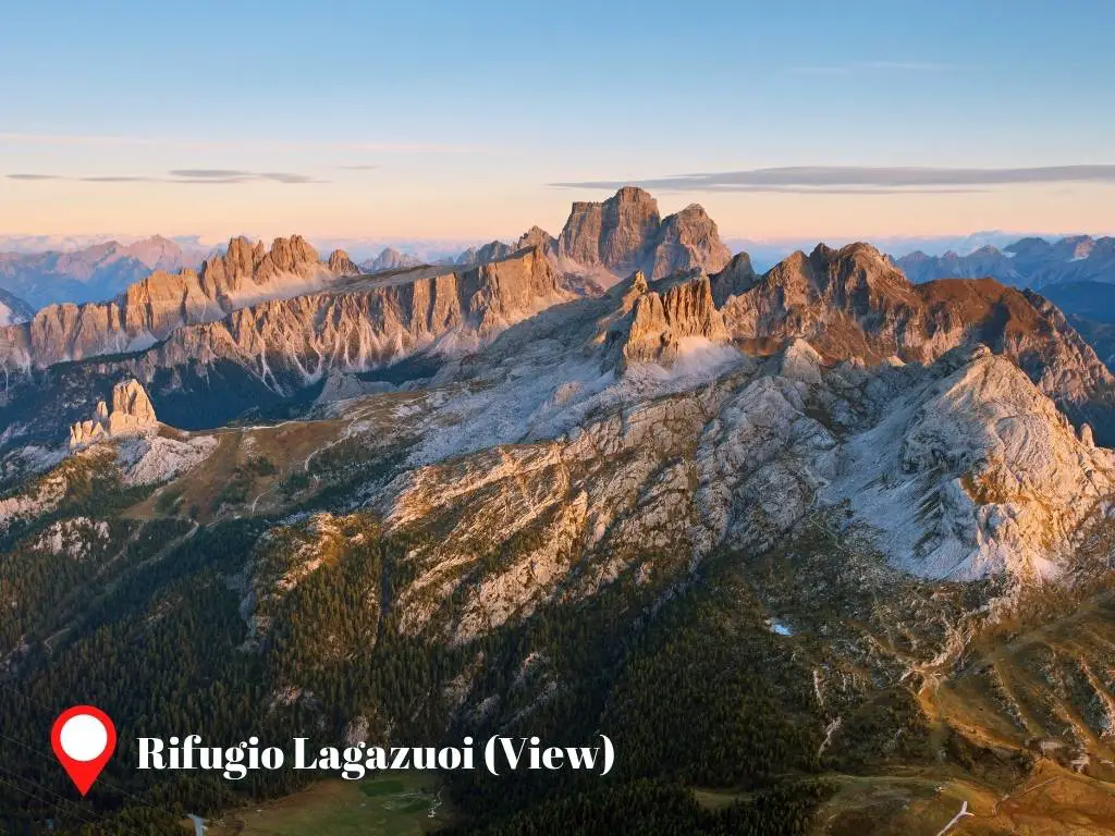
A visit to Rifugio Lagazuoi, much like trips to Cinque Torri and Tre Cime di Lavaredo, offers a fascinating peek into history. The area is dotted with remnants of its military past, including a tunnel and bunkers constructed by the Italian military. Keep an eye out for openings that were once used by soldiers to fire cannons; some of these offer stunning views.
As the day draws to a close, the terrace of Rifugio Lagazuoi provides an unparalleled vantage point for sunset viewing.
While it’s dependent on the weather, on a clear day, you might be fortunate enough to witness a breathtaking panorama of mountain silhouettes layered against the horizon, gradually fading into varying shades of blue under a golden sky.
For an even more panoramic view, consider hiking to the summit of Lagazuoi Piccolo.The hike from Rifugio Lagazuoi to the summit is a leisurely 12 to 15-minute stroll along a well-maintained path. Rifugio Lagazuoi is conveniently located just above Passo Falzarego, a mountain pass linking Cortina d’Ampezzo with towns in South Tyrol.
Along this pass, you’ll find the Lagazuoi Cable Car, which simplifies the journey to Rifugio Lagazuoi.
The valley station of the Lagazuoi Cable Car is a mere 16.5 kilometers from Cortina d’Ampezzo, which translates to a 25-minute drive from the town center. This station is also the final stop for Bus #030 services from Cortina d’Ampezzo. If you opt for the bus, plan for a travel time of approximately 35 minutes to reach the Lagazuoi Cable Car.
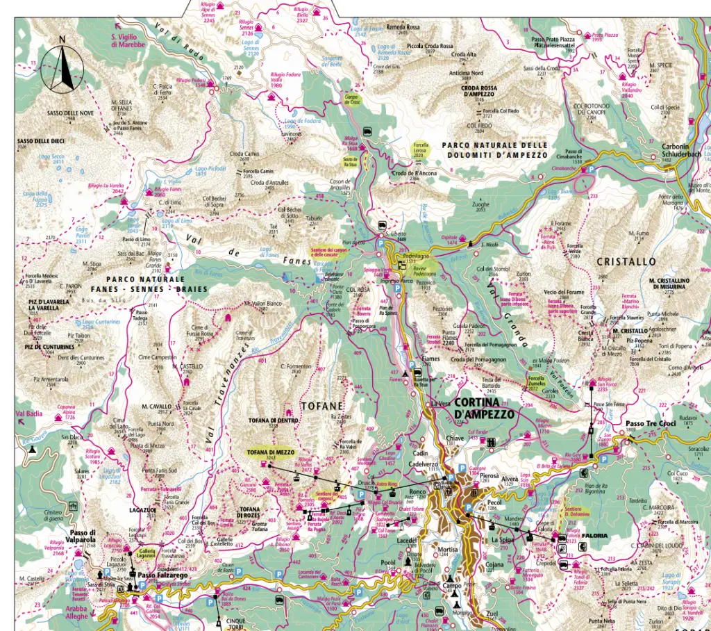
Map of Attractions Near Cortina d’Ampezzo
Here is the summary of the places near Cortina d’Ampezzo we discussed above. The roads to the parking spaces for each destination are indicated. The hiking trails are shown in the next section.
If you need a place to stay in Cortina d’Ampezzo, you can find the best hotel deals in Cortina d’Ampezzo here. It is a hotel finder with a map feature to help you quickly find the hotels at the most accessible/convenient location.
Also, do you need one of these?
- Day tours from Milan, Venice, and Bolzano
- Day tours of the Dolomites from Cortina
- Express bus service
- Guided Tours
See this list of services in Cortina d’Ampezzo. They may help you to visit the Dolomites.
Cortina d’Ampezzo: Location & Arrival
As the town at the heart of the Dolomites, Cortina d’Ampezzo is affectionately known as the “Queen of the Dolomites.” Situated in Northern Italy, Cortina d’Ampezzo can be reached from different cities.
Below is how you can get to Cortina d’Ampezzo from different cities in Italy and Austria.
- Venice: If you’re starting your journey in Venice, the quickest way to reach Cortina d’Ampezzo is by car, which will take around 1 hour and 45 minutes. Alternatively, you can opt for a more relaxed bus ride, which will get you there in approximately 2 hours and 45 minutes.
- Verona: From Verona to Cortina d’Ampezzo, you can hit the road and arrive in roughly 2 hours and 46 minutes by following the E70 and A27 routes. Alternatively, you can choose to take a bus from Verona with a transfer in Varna, which offers a convenient alternative.
- Innsbruck: When coming from Innsbruck, the fastest way to reach Cortina d’Ampezzo is by driving, taking approximately 2 hours and 6 minutes. If you prefer public transportation, you can catch a bus from Innsbruck Airport to Dobbiaco and then transfer to a line 445 bus that will take you to Cortina d’Ampezzo.
- Bolzano: Traveling from Bolzano to Cortina d’Ampezzo can be done by car in about 1 hour and 41 minutes. Alternatively, you can take a train from Bolzano Bozen to Fortezza/Franzensfes, then another train from Fortezza/Franzensfes to Dobbiaco Toblach, and finally, complete your journey with a line 445 bus from Dobbiaco – Stazione to Cortina d’Ampezzo.
For your convenience, here’s the bus tickets and private transfers to Cortina d’Ampezzo.
Where to Stay in Cortina d’Ampezzo
Depending on your preferences and budget, you can stay in different areas of Cortina, each with its own advantages and disadvantages. Here are some of the best areas to stay in Cortina d’Ampezzo:
- Largo delle Poste: This is the central area of Cortina, where you can find everything you need. There are many hotels, shops, restaurants, and bars in this area, so you will never get bored. You can also easily reach the Faloria cable car, which takes you to the ski slopes and hiking trails. The benefits of staying in this area are the convenience, the variety, and the lively atmosphere. The drawbacks are the higher prices, the noise, and the lack of parking spaces.
- Località Pocol: This is a quieter and more scenic area of Cortina, located about 4 km from the town center. It is ideal for nature lovers, as it offers panoramic views of the mountains and easy access to the ski slopes and hiking trails. The benefits of staying in this area are the tranquility, the beauty, and the lower prices. The drawbacks are the distance from the town center, the limited public transportation, and the fewer amenities.
- Località Fiames: This is another peaceful and picturesque area of Cortina, located about 3 km from the town center. It is close to the Natural Park of the Ampezzo Dolomites, where you can enjoy various outdoor activities. The benefits of staying in this area are the serenity, the nature, and the moderate prices. The drawbacks are the remoteness from the town center, the scarce public transportation, and the lack of nightlife.
If you need a place to stay in Cortina, you can find the best hotel deals in Cortina here.
Best Way to Travel Around Cortina d’Ampezzo
The transportation options in Cortina d’Ampezzo are important to consider when you decide where to go next from the town. The only ways to get to Cortina are by bus or private vehicle, and that’s also how you can visit the attractions around it.
There are no trains in Cortina, but you can use cable cars to get around. If you want more flexibility and efficiency in your itinerary, renting a car or a private vehicle is the best option. This is especially true in the non-summer season, when some bus lines and cable cars are not running.
You can find the map of Cortina’s bus network below, courtesy of the Cortina Tourism Information Office. And you can also check the bus schedules by downloading the PDF from their website.
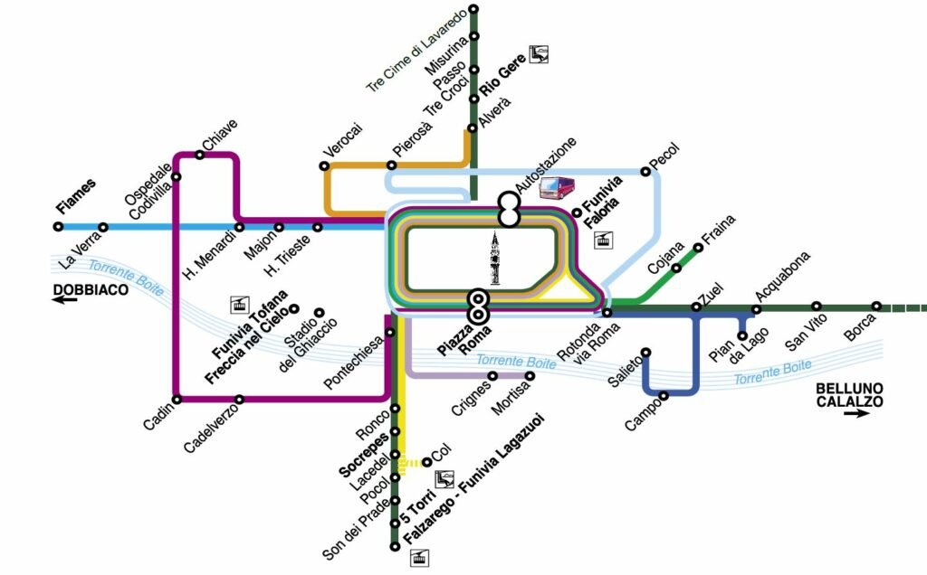
You can check the Information Center to see the current price of the bus tickets and where to buy them.
At the end of this post, I’ll share a map of Cortina d’Ampezzo, including trail numbers and itineraries. You can use this map to plan your hikes and estimate the time needed for each one. Additionally, I’ll provide my own estimates (using the Komoot route planner) for your convenience.
Tips for Using the Lifts in Cortina d’Ampezzo
When exploring Cortina d’Ampezzo, you’ll likely be using lifts and cable cars to get around.
Knowing which passes/tickets to purchase can help you save money and provide added convenience when visiting local attractions. There are different types of tickets for different seasons and activities. Let me explain them to you:
- For the summer season, you have three options: the Cortina Vertical Pass, the Cortina Bike Pass, and the Dolomiti SuperSummer ticket.
- The Cortina Vertical Pass is for people who love hiking, running, climbing, or just enjoying nature. You can buy a pass for 1, 3, 5, or 7 days, and use it on any day you want. You can also buy a pass for the whole summer season. With this pass, you can access all the lifts that are open in the summer .
- The Cortina Bike Pass is for bikers who want to have fun on the trails and tracks in the area. You can buy a pass for 1 or 3 days, and use it on any day you want. With this pass, you can access all the lifts that allow you to take your bike with you, except for the Lagazuoi cable car .
- The Dolomiti SuperSummer ticket is for people who want to explore more than just Cortina d’Ampezzo. You can buy a ticket for one or more days, and use it on any of the 100 lifts in 12 ski areas in the Dolomites. You can also choose a ticket based on points instead of days. With this ticket, you can also enjoy other attractions and activities, such as museums, observatories, exhibits, and cultural walks .
- For the winter season, you have three options: the Cortina d’Ampezzo Ski Pass, the Dolomiti Superski Pass, and the Skiworld Ski Pass.
- The Cortina d’Ampezzo Ski Pass is for skiers and snowboarders who want to experience the charm and beauty of Cortina d’Ampezzo. You can buy a pass for one or more days, and use it on all the lifts and slopes in Cortina d’Ampezzo. You can also buy a pass for the whole winter season.
- The Dolomiti Superski Pass is for skiers and snowboarders who want to explore more than just Cortina d’Ampezzo. You can buy a pass for one or more days, and use it on all the lifts and slopes in 12 ski areas in the Dolomites, including Cortina d’Ampezzo. You can also buy a pass for the whole winter season.
- The Skiworld Ski Pass is for skiers and snowboarders who want to enjoy different landscapes and atmospheres in four destinations: Cortina d’Ampezzo, San Vito di Cadore, Auronzo/Misurina, and Comelico/Danta. You can buy a pass for one or more days, and use it on all the lifts and slopes in these locations. You can also buy a pass for the whole winter season.
Here are the links where you can find more information about Summer Passes/Cards and Winter Passes/Cards.
You have two options to purchase passes: online or in-person at the Lift Ticket Booths or offices listed in the links.
To stay up-to-date on the status and schedule of each lift and cable car in Cortina d’Ampezzo, check out the following links below.
Before you head out to explore the areas around Cortina d’Ampezzo, it’s a good idea to check the weather conditions using live cameras. This is especially important if it’s not looking like a sunny day. That way, you can avoid wasting your time and energy on a view that’s obscured by fog or clouds.
You can get a guide in hiking and exploring the Dolomites from this link.
Where To Go After Cortina d’Ampezzo?
Cortina d’Ampezzo is a nature lover’s dream destination in Italy, and I’m no exception.
If you’re looking for similar places to visit, I recommend Chamonix in France, Switzerland, and Bavarian Alps in Southern Germany. In Switzerland, the Zermatt and Jungfrau Region, comprised of Interlaken, Lauterbrunnen, and Grindelwald, are must-see.
If want to visit the aforementioned destinations from Northern Italy, you have a couple of options. You could either catch a train or book a flight to the nearest cities. In Switzerland, your journey can commence from Zurich, Geneva, Basel, or Bern. In Germany, Munich would be your starting point. And in France, consider beginning your trip from either Lyon or Annecy.
On the other hand, if you want to stay in Italy and explore its most scenic cities, I suggest Bolzano and Trento. They are very close to Cortina d’Ampezzo. Actually, you have to pass through these cities before reaching Cortina d’Ampezzo if you are from Venice or Verona.
Suppose you’re looking for a leisurely journey or an extended holiday in Northern Italy. In that case, you might want to consider the following itinerary sequence below.
Cortina →Bolzano (2.5 hours by car from Cortina) →Trento (30 minutes by train from Bolzano) →Verona (1 hour by train from Trento) →Lake Garda (15 minutes by train from Verona) →Milan (1 hour by train from Lake Garda) →Bergamo or Lake Como (1 hour by train from Milan) or Cinque Terre (3.5 hours by train from Milan)
Or
Cortina →Bolzano (2.5 hours by car from Cortina) →Trento (30 minutes by train from Bolzano) →Verona (1 hour by train from Trento) →Venice (1.5 hours by train from Verona) →Florence (2.5 hours by train from Venice) →Rome (1.5 hours by train from Florence)
Learn more about Lake Garda, Lake Como, Cinque Terre, Bergamo, Milan, Florence and Rome.
Trail Numbers and Hiking Map in Cortina d’Ampezzo
While our phones’ GPS systems are incredibly handy, it’s always beneficial to have a solid understanding of the hiking trails in Cortina d’Ampezzo, including their routes and various forks.
So, to assist you in planning your exploration of the stunning lakes and mountains around Cortina d’Ampezzo, I’ll be sharing detailed maps and trail information for each hike in the following sections.
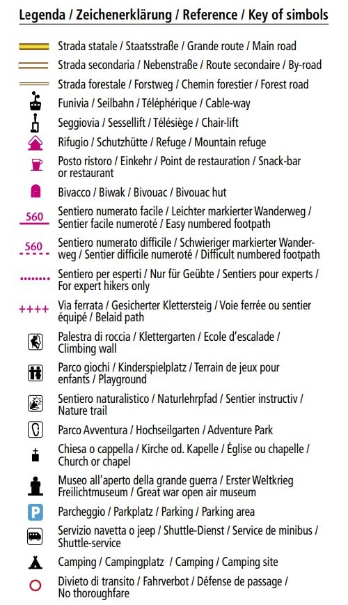
The information written below is gathered from the brochure from dolomiti.org.
You can check their website to download a printable version or just bookmark/save this page for more convenience. 🙂 I hope you find this section very helpful!
You can get a guide in hiking and exploring the Dolomites from this link.
Trail 3 to 34: Parco Naturale delle Dolomiti Ampezzane – Parco Naturale di Fanes, Sennes e Braies
| Trail Number | Itinerary | Hours Required |
|---|---|---|
| 3 | Pratopiazza – Campo Latino | 3h 30m |
| 4 | Campo Latino – Porta Sora el Forn – Rifugio Biella | 2h |
| 6 | S. Uberto – Malga Ra Stua – Rifugio Sennes – Rifugio Biella | 4h |
| 7 | Rifugio Sennes – Fodara Vedla – Pederu | 3h |
| 8 | Cimabanche – Forcella Lerosa – Malga Ra Stua | 3h |
| 9 | Ciampo de Crosc – Rudo – Lago de Fodara – Rifugio Fodara Vedla | 1h 30m |
| 10 | Pian de Loa – Val de Fanes – Rifugio Fanes – Rifugio La Varella | 3h 30m |
| 11 | Alpe di Fanes Grande – Passo Tadega – Armentarola | 3h 30m |
| 17 | Val Travenanzes – Forcella Casale – Alpe Fanes Grande | 4h |
| 18 | Cimabanche – Vai del Chenopi – Pratopiazza | 2h |
| 20 | Rifugio Lagazuoi – Val Lagazuoi – Capanna Alpina | 1h 30m |
| 1020 | Rifugio Lagazuoi – Forcella Travenanzes – Bivacco Dalla Chiesa – Rif. Scotoni | 3h |
| 26 | Ciampo de Crosc – Crosc del Grisc – Alpe di Fosses – Rifugio Biella | 3h |
| 28 | Rifugio Biella – Forcella Cocodain – Malga Cavallo | 2h 30m |
| 31 | Alpe di Fosses – Forcella Cocodain | 1h |
| 34 | Landro – Val Chiara – Rifugio Vallandro | 3h |
Trail 101 to 122: Misurina – Tre Cime di Lavaredo
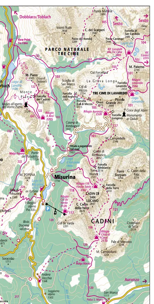
| Trail Number | Itinerary | Hours Required |
|---|---|---|
| 101 | Rifugio Auronzo – Rifugio Locatelli/Tre Cime | 2h |
| 102 | Landro – Val Rimbon – Rifugio Locatelli | 4h |
| 103 | Casera Rinbianco – Val Rimbon | 2h |
| 115 | Misurina – Pian dei Spiriti – Rifugio Fonda Savio | 2h 30m |
| 117 | Col de Varda – Cadin della Neve – Rifugio Fonda Savio Rifugio Auronzo | 4h |
| 118 | Misurina – Forcella della Neve – Rifugio Citta di Carpi | 4h 30m |
| 120 | Misurina – Col de Varda – Maraia Alte – Palus San Marco | 4h |
| 122 | Misurina – Rif. Bosi – Monte Piana – Forcella dei Castrati | 2h |
Trail 201 to 233: Pomagagnon – Cristallo – Faloria – Sorapis
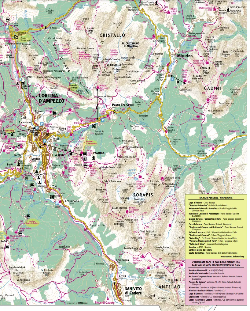
| Trail Number | Itinerary | Hours Required |
|---|---|---|
| 201 | Ponte sul Rio Felizon – Podestagno – Val Granda – Incrocio con sentiero 202 | 2h 30m |
| 202 | La Vera – Sote el Pomagnagon – Forcella Pomagnagon – Val Padeon | 4h |
| 203 | Ospitale – Val Padeon – Son Forca – Passo Tre Croci | 3h 30h |
| 204 | Chiave – Mietres – Forcella Zumeles – Val Padeon | 3h |
| 205 | Forcella Zumeles – Son Forca | 30m |
| 206 | Stazione intermedia della funivia del Faloria – Pezies – Malga Larieto – Po Pontio | 2h |
| 207 | Grava di Sopra – Col Tondo | 30m |
| 208 | Cimabanche ad Acquabona per it vecchio tracciato della ferrovia | |
| 209 | Alvera – Lago Scin – Rio Gere – Passo Tre Croci – Valbona | 4h |
| 210 | Albergo Cristallo – Mandres – Costalaresc – Lago Scin | 1h 30m |
| 211 | Fiames (Lago de Ra Ranes) – Bruja del Pomagagnon – Mietres – Rio Gere | 3h |
| 212 | Mandres – Crepedel – Rifugio Faloria – Pian de Ra Bigontina – Rio Gere | 4h |
| 213 | Rifugio Faloria – Tardeiba – Passo Tre Croci | 3h 30m |
| 214 | Fraina -Val Orita – Rifugio Faloria | 3h 30m |
| 215 | Passo Tre Croci – Rifugio Vandelli al Sorapis – Sella di Punta Nera – Rifugio Tondi | 6h |
| 216 | Tardeiba – Forcella Marcoira – Rifugio Vandelli al Sorapis | 2h 30m |
| 217 | Valbona – Sopis – Val del Pisciandre – Rifugio Vandelli al Sorapis | 2h |
| 220 | Pezie – Fraina – Sote Crepedel – Pecol | 1h |
| 221 | Passo Tre Croci – Col de Varda – Grave de Cerigere – Passo del Cristallo | 3h 30m |
| 222 | Ponte Rudavol – Val Popena Alte – Ponte Popena | 3h 30m |
| 223 | Tondi di Faloria – Forcella Ciadin del Loudo – Ciadin del Loudo | 2h |
| 225 | Chiapuzza – Val Popolada – Rifugio San Marco | 4h |
| 226 | Rifugio San Marco – Val di San Vito – Palus San Marco | 5h |
| 227 | Rifugio San Marco – Rifugio Galassi | 1h 30m |
| 233 | Cimabanche – Pra del Vecia – Forcella Verde – Forcella Grande | 5h |
Trail 401 to 466: Passo Falzarego – Passo Giau – Tofana – Lagazuoi – Cinque Torri – Averau – Nuvolau – Croda da Lago
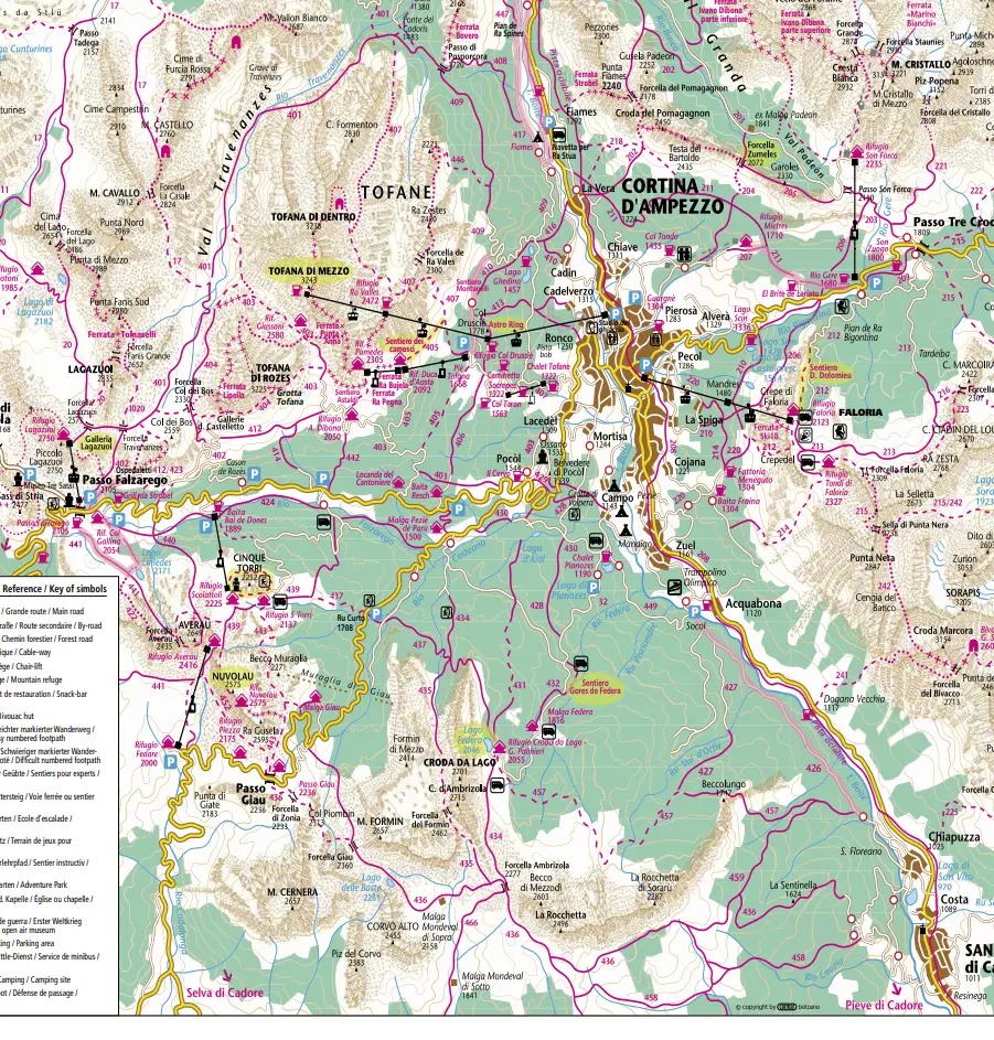
| Trail Number | Itinerary | Hours Required |
|---|---|---|
| 401 | Pian de Loa – Val Travenanzes – Rifugio Lagazuoi | 4h 30m |
| 402 | Cason de Rozes – Forcella Col dei Bos – Forcella Travenanzes – Passo Falzarego | 3h |
| 403 | Lacedel – Pocol – Rifugio Son dei Prade – Fedarola – Rifugio Dibona – Rifugio Giussani – Masarie – Val Travenanzes | 6h |
| 404 | Valon de Tofana – Forcella Col dei Bos | 1h |
| 405 | Pie Tofana – Rifugio Duca d’Aosta – Pocol de Ra Crosc | 2h |
| 406 | Vervei – Maiorera – Rumerlo | 45m |
| 407 | Pie Tofana – Forcella Ra Valles – Graon de Ra Ola – Ponte dei Cadoris | 5h |
| 408 | Pian de Ra Spines – Val Fiorenza – Passo Posporcora – Ponte dei Cadoris | 3h |
| 409 | Lago Ghedina – Cianderou – Passo Posporcora | 2h |
| 410 | Cadin di Sopra – Lago Ghedina – Pie Tofana | 1h 30m |
| 412 | Valon Tofana – Sotecordes – Col dei Bos | 1h 30m |
| 413 | Ronco (pista bob) – Pian del Rasaduoi – Strada Laghi Ghedina – Col Druscie | 1h 30m |
| 414 | Ponte sul Ru Bianco – Sotecordes | 1h |
| 416 | La Vera – Ponte de Ra Piencia – Lago Ghedina | 30m |
| 417 | Cadin di Sopra – Campeggio Olimpia – Pian de Ra Spines – Ponte sul Rio Felizon | 1h 30m |
| 419 | Rifugio Col Gallina – Lago de Limides – Forcella Averau | 1h 30m |
| 420 | Rifugio Duca d’Aosta – Rifugio Pomedes | 45m |
| 421 | Rifugio Dibona – Rifugio Pomedes | 1h |
| 422 | Limides – El Coolo – Forcella Averau | 2h |
| 423 | Passo Falzarego – Ospedaletti – lncrocio sent. 402 | 1h |
| 426 | Socol – Pontes de Val d’Ortie – Ponte Geralba | 1h 30m |
| 427 | Socol – Ponte dei Aiade – Pian de Ra Baita | 2h |
| 428 | Mortisa – Ponte Outo de Ra Costeana – Cesura Granda – Col Purin | 1h 30m |
| 429 | Volpera – Crepa – Belvedere | 1h 30m |
| 430 | Pianozes – Lago d’Ajal – Ciou del Conte – Ra Spada | 1h 30m |
| 431 | Lago d’Ajal – Beco d’Ajal – Croda da Lago | 2h 30m |
| 432 | Campo di Sotto – Pianozes – Col Purin – Malga Federa – Rif. Croda da Lago | 3h 30m |
| 434 | Pezie de Para – Alpe del Formin – Ciadenes – Croda da Lago – Forcella Ambrizola | 3h |
| 435 | Alpe del Formin – Val Formin – Forcella Ambrizola | 3h |
| 436 | San Vito – Alpe Prendera – Col Duro – Mondeval – Forcella Giau – Passo Giau | 6h |
| 437 | Alpe del Formin – Ru Curto – Ciampo dei Toulas – Rifugio Cinque Torri | 2h 30m |
| 438 | Passo Giau – Ferrata della Gusela – Rifugio Nuvolau | 2h 30m |
| 439 | Cianzope – Saresin – Ra Boa – Rifugio Cinque Toni – Rifugio Nuvolau | 2h 30m |
| 440 | Pian dei Menis – Alpe Potor – Forcella Nuvolau | 1h 30m |
| 441 | Passo Falzarego – Limides – Forcella Averau – Forcella Nuvolau – Lasta del Nuvolau | 2h |
| 442 | Cianzope – Miliera – Rifugio Dibona | 1h 30m |
| 443 | Rifugio Cinque Torri – Beco Muraglia – Passo Giau | 1h 30m |
| 445 | Ciou del Conte – Strada Statale 48 delle Dolomiti | 45m |
| 446 | Cianderou – Tonde de Cianderou – Ra Zestes – Forcella Ra Valles | 2h 30m |
| 447 | Pian de Ra Spines – Col Rosa | 3h 30m |
| 449 | Socol – Lago de Pianozes | 30m |
| 450 | Cadelverzo – Pian del Rasaduoi – Lago Ghedina | 30m |
| 451 | Campo – Cu de Col – Pocol – Belvedere – Crosc de Ester | 2h |
| 452 | Passo Giau – Masarei d’Avoi – Forcella Nuvolau | 1h 15m |
| 457 | Taula Salvaniera – Beco Longo – Pian de Ra Baita – Rifugio Croda da Lago | 5h |
| 466 | Forcella Ambrizola – Malga Mondeval – Val Fiorentina | 3h |
Save it on Pinterest.


Your information on the area is very appreciated. We plan on going near the area in September. This will be my 3rd visit to the Dolomites. I absolutely love this area of Italy! We will probably stay at an Agritourismo this time. I have driven through Cortina but haven’t spent time there. Thank you for all the detailed information.
Susie
Thank you very much! ❤️❤️